TAMPA, Fla. (WFLA) — As the 2023 hurricane season enters its final stretch, the El Niño weather pattern has shown up in full force.
El Niño is one of the two phases in the El Niño-Southern Oscillation phenomenon. During this stage, trade winds weaken, causing warm Pacific Ocean water to move toward the Americas, according to the National Oceanic and Atmospheric Administration (NOAA).
This climate pattern had a big impact on the 2023 hurricane season. With 19 named storms, the season was considered active, but thanks to the El Niño, few Atlantic cyclones ended up reaching the mainland U.S.
“It really shows how different the weather pattern was this year with El Niño bringing warmer than normal sea surface temperatures in the Atlantic, and how that really played out to be fish storm, after fish storm, after fish storm,” WFLA meteorologist Rebecca Barry said.
Barry said the storms helped to cool down the abnormally warm Atlantic ocean, but not so much the record-breaking sea surface temperatures in the Gulf.
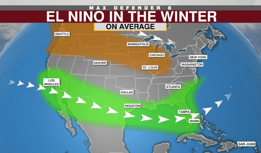
“Now, as we head into the winter months, El Niño is beginning to take shape,” WFLA meteorologist Amanda Holly said. “Typically, in the summertime with El Niño, we would have fewer storms develop because of that lower wind shear in the Atlantic. Heading into the winter months, it translates to more Gulf systems developing.”

Holly said that areas of low pressure have been forming, feeding off the warm Gulf waters as they skirt along the coast towards Florida. This pattern is expected to continue for the next several months.
El Niño brings with it an active subtropical jet stream, which means a wetter, cooler winter for the Gulf coast as frequent fronts and storms sweep through. There are more cloudy days, which also helps to keep things cool.
“Unfortunately, with those storm systems, we can see more frequent severe weather, with stronger storms and tornadoes,” Holly said. “So that is something we’ll have to watch with these systems.”

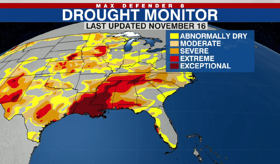
Those storms will bring some much-needed rain to the region. Most of the Gulf coast is experiencing drought conditions, as of Nov. 16.
“Louisiana is covered by the most extreme category of severe drought you could possibly see, so we’ll certainly take the rain at this point,” Holly said.
The tropics have been mostly quiet this week, with the National Hurricane Center tracking a single disturbance with a slight chance of development on Wednesday. The non-tropical low is expected to drift northeastward over the Atlantic and poses no threat to the mainland U.S.
It’s not out of the question for a tropical system to pop up in the southern Atlantic in the coming weeks, but the chances become less likely as the ocean cools down for winter.
Watch Tracking the Tropics Wednesdays at 12:30 p.m. ET/11:30 a.m. CT.
Be prepared with the WFLA Hurricane-Ready Guide 2023 and stay ahead of tropical development with the Tracking the Tropics newsletter.


