TAMPA, Fla. (WFLA) — Hurricane Idalia is forecast to make landfall in northwest Florida Wednesday as an “extremely dangerous” Category 3 major hurricane — But that may not be its last time striking the Sunshine State.
Some long-range models suggest Hurricane Idalia may loop south and back toward Florida’s Atlantic coast and impact the state north of West Palm Beach. However, it should be noted these long-range models are prone to inaccuracies and are subject to change.

In order for Idalia to return to South Florida, the storm would have to rekindle thunderstorms around its center and start the development process a second time.
Some Florida residents may recall a similar sequence of events when Hurricane Ivan followed a southwestern track in 2004.
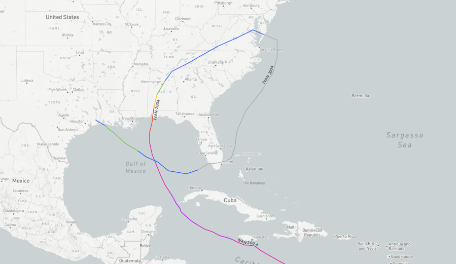
Ivan reached Category 5 strength three times on its long and destructive path through the Caribbean and the United States. After plowing through Alabama, Ivan emerged into the western Atlantic Ocean as an extratropical cyclone.
From there, Ivan turned southwest towards Florida’s southern peninsula before crossing back into the Gulf of Mexico.
The cyclone then strengthened into a tropical storm once more before making landfall in Louisiana and dissipating across eastern Texas.
Ivan ultimately brought unwanted rains to already inundated areas of Texas and Florida, leaving 8 dead in the western Florida Panhandle.
Watch WFLA Now‘s 24/7 coverage to stay up-to-date on Idalia. Get the latest on closings and weather conditions in your area on our Tracking the Tropics page.


