TAMPA, Fla. (WFLA) — Hurricane Idalia is making its way toward Florida’s Gulf Coast, and as Idalia nears, storm surges across the Tamp Bay area are expected. Due to Wednesday’s Super Moon causing higher-than-normal high tides, the storm surge threat has increased.
According to the National Hurricane Center, Idalia will have “catastrophic” impacts from storm surge, but when can Tampa Bay expect to see those impacts?
The worst weather will be between Tuesday night and Wednesday afternoon. However, the biggest storm surge for the Tampa Bay area will occur after the eye of the storm passes Wednesday afternoon.
What is storm surge?
As Hurricane Idalia churns over the ocean, strong winds push the water, causing it to pile up on the coast.
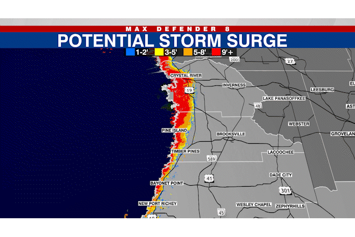
The NOAA defines storm surge as the abnormal rise of water generated by a storm, over and above the predicted astronomical tide. According to the NHC, the tide and storm surge together could reach up to 20 feet.
In the past, large death tolls have resulted from the rise of the ocean associated with many of the major hurricanes that have made landfall, according to the NOAA.
Tracking Hurricane Idalia
As of a 4 a.m. update, the National Hurricane Center said Idalia is about 90 miles west-southwest of Cedar Key, moving north at around 17 mph. Idalia is a Category 3 hurricane, with wind speeds increasing to 125 mph.
Idalia is forecast to track west of Tampa and make landfall along the northwest Gulf Coast of Florida sometime on Wednesday as an “extremely dangerous” Category 4 major hurricane, the NHC said.
Storm surge remains the biggest threat with Idalia, with some areas north of Tampa Bay expected to see 8 to 15 feet of storm surge, with 4 to 7 feet in the Tampa Bay area and 3 to 5 feet south of Tampa Bay around 1 p.m.
“The impacts will definitely be a little stronger in our coastal counties,” Max Defender 8 Meteorologist Rebecca Barry said. “The worst of the surge is now in northern Citrus County. They did downgrade the surge for southern Citrus County to that 6 to 9-foot range instead of above 9 feet, so that’s good.”
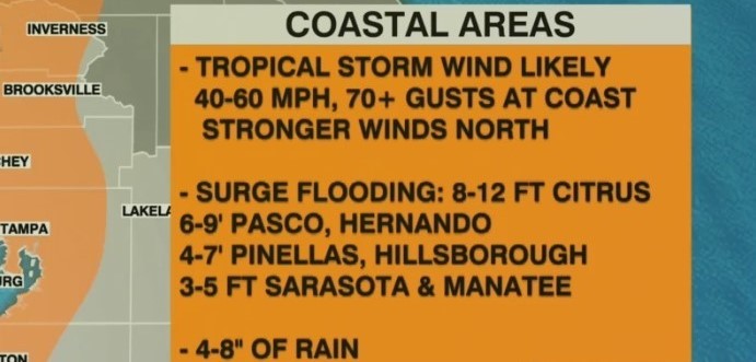
Surge flooding in Citrus County is expected to be 8 to 12 feet. Pasco and Hernando Counties can expect 6 to 9 feet, Pinellas and Hillsborough could see 4 to 7 feet, while Sarasota and Manatee Counties could see 3 to 5 feet.


