This is story is now archived. Click here for the latest on Tropical Storm Ian’s progress.
TAMPA, Fla. (WFLA) — The tropical system that is expected to move into the Gulf of Mexico next week and approach Florida as a major hurricane became Tropical Storm Ian on Friday and is expected to become a tropical storm soon.
Tropical Storm Ian formed over the Caribbean Sea Friday evening. According to the 11 p.m. ET outlook from the National Hurricane Center, the system is about 385 miles southeast of Kingston, Jamaica with maximum sustained winds of about 40 mph.
According to the National Hurricane Center, strengthening is forecast during the next few days, and Ian is
expected to become a hurricane Sunday night.
A hurricane watch was issued Friday evening for the Cayman Islands including Grand Cayman, Little Cayman and Cayman Brac. A tropical storm watch was issued in Jamaica.
The NHC says people in Cuba, the Florida Keys and the Florida peninsula should keep a close eye on the system as it nears the Gulf.
Latest track

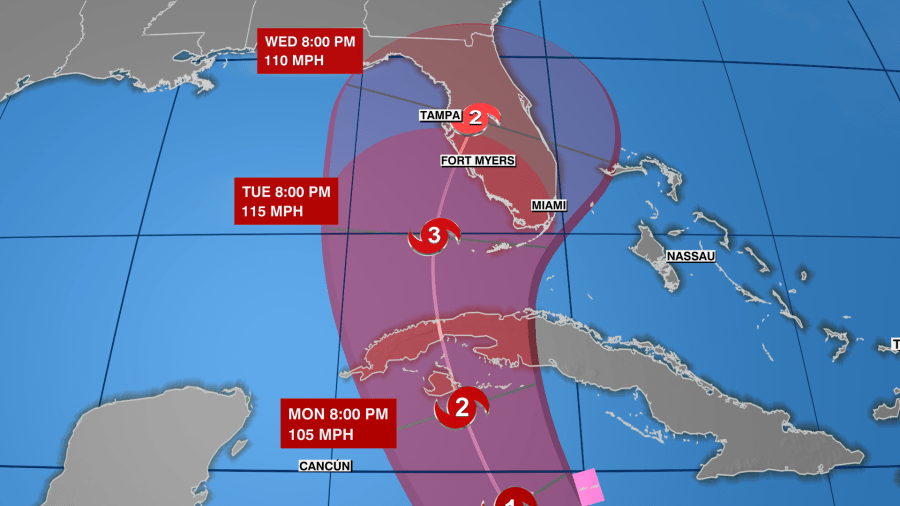
The current forecast track shows the system moving west-northwest, moving over the central Caribbean Sea through Saturday, passing south of Jamaica Saturday night and Sunday, then approaching the Cayman Islands on Sunday night or early Monday. Slow strengthening is expected in the next few days, followed by more “significant intensification” Sunday and Monday.
Environmental conditions also appear favorable for the system once it reaches the Gulf of Mexico.
“The National Hurricane Center calls for a Category 3 hurricane – a major hurricane – approaching the west coast of Florida early to mid-next week,” Holly said. “Forecast models have come in better agreement now that we have a closed center of circulation.”
However, Holly says some shifts to the track are expected over the next several days as we monitor the storm and get a more clear picture of the system.
Impacts
Tropical Storm Ian is expected to bring heavy rain and gusty winds to the Windward Islands, northern Venezuela and Colombia, Aruba, Bonaire and Curaçao. Those areas could see up to 1 to 2 inches of rain while southern Haiti and the Dominican Republic, recently battered by Hurricane Fiona, could get 2 to 4 inches of rain with a maximum of 6 inches.
However, even heavier rains are expected for Jamaica, Cuba and the Cayman Islands. Jamaica and Cuba could particularly see mudslides and flash flooding in areas of high terrain.
The NHC says once it’s in the Gulf and approaches land at or near major hurricane strength, there is a potential for significant storm surge, wind and rainfall impacts.
“While it is too soon to determine the exact magnitude and location of these impacts, residents in Cuba, the Florida Keys and the Florida Peninsula should ensure they have their hurricane plan in place and closely monitor forecast updates through the weekend.”
Elsewhere in the tropics
Tropical Depression 10 also formed Friday morning, and strengthened Friday evening to become Tropical Storm Hermine. It poses no threat.
Hurricane Fiona remains a powerful storm heading toward Canada.
Tropical Storm Gaston has strengthened and is moving toward the Central Azores.
Tracking the Tropics streams at 2 p.m. ET every Wednesday during hurricane season. For the latest updates, check out our Tracking the Tropics website.


