TAMPA, Fla. (WFLA) – The fourteenth and fifteenth named storms of the Atlantic hurricane season developed just hours apart on Tuesday as we get closer to the statistical peak of the season.
Tropical Storm Nana formed just after noon from Potential Tropical Cyclone 16. Tropical Storm Omar formed around 5 p.m. in the Atlantic.
Tropical Storm Nana
Tropical Storm Nana in the Caribbean, becoming the earliest “N” named storm on record, according to Dr. Philip Klotzbach with Colorado State University.
Nana is about 425 miles east of Limon, Honduras and is moving west at 18 mph. The storm is expected to move near, but north, of the Honduras coast on Wednesday. The National Hurricane Center says it will then likely approach the coast of Belize Thursday.
As of 5 p.m. Tuesday, Nana has maximum sustained winds of 50 mph. The NHC says strengthening is expected in the next 48 hours and Nana could become a hurricane before its expected landfall on Thursday.
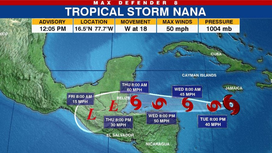
A Tropical Storm Watch is in effect for Northern Honduras, Roatan Island, the Bay Islands of Honduras, the Caribbean Sea coast of Guatemala and Belize.
A Tropical Storm Watch has been issued in Yucatan, Mexico from Puerto Costa Maya to Chetumal.
Tropical Storm Omar
Tropical Depression 15 formed in the Atlantic Monday evening strengthened to become Tropical Storm Omar around 5 p.m. Tuesday off the coast of North Carolina.
The NHC says Omar is about 225 east of Cape Hatteras and is moving east-northeast. Omar is forecast to continue moving away from North Carolina and out to sea. It is not expected to impact land.
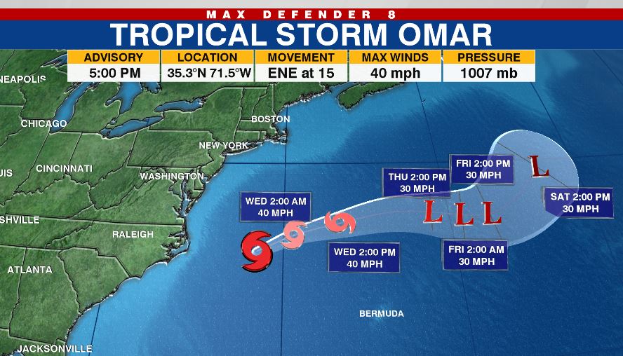
At 5 p.m., Omar had reached maximum sustained winds of 40 mph. The NHC does not expect much change in strength overnight but says the storm will likely start weakening Wednesday before becoming a remnant area of low pressure by late Thursday.
Other areas to watch
The NHC is also keeping an eye on two areas that could eventually develop.
The first is an area of low pressure between the Windward Islands and west Africa. The NHC has given it a low 10 percent chance of formation in the next 48 hours and a low 20 percent formation chance through the next five days.
“Upper-level winds are marginally conducive for some slow development this week as the system meanders in the central tropical Atlantic Ocean,” the NHC said.
Forecasters are expecting a tropical wave to emerge off the coast of Africa soon and merge with a disturbance near the Cabo Verde Islands.
“Gradual development of this system is then possible, and this system could become a tropical depression by this weekend while it moves slowly westward over the eastern tropical Atlantic Ocean,” the NHC said.
The wave has been given a low zero percent change of formation in the next 48 hours and a medium 50 percent chance of formation through the next five days.
TRACKING THE TROPICS:
- Hurricane Idalia claimed 12 lives, caused $3.6B in damage, NHC report finds
- Tracking the Tropics ends for the season
- Tracking the Tropics team takes a look back at the 2023 hurricane season
- What does the El Niño weather pattern mean for winter?
- Late-season system in Atlantic has 60% chance of development, NHC says


