TAMPA, Fla. (WFLA) – Two tropical depressions are both expected to strengthen and become tropical storms as soon as Thursday.
Tropical Depression 13 formed in the Atlantic Wednesday night. About 12 hours later, Tropical Depression 14 formed in the Caribbean Sea. Whichever depression strengthens first will get the name Laura. The following storm will be Marco.
Tropical Depression 13
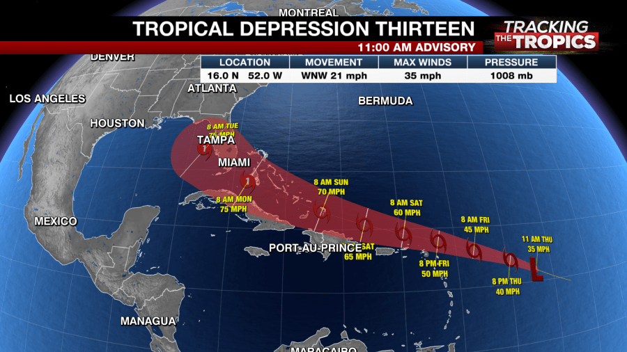
Tropical Depression 13 formed in the Atlantic on Wednesday night. It’s about 715 miles east of the Northern Leeward Islands and is moving west-northwestward with 35 mph maximum sustained winds.
According to the National Hurricane Center, the depression is expected to become a tropical storm later Thursday.
“The latest update that came in at 11 a.m. does strengthen this to a Category 1 hurricane somewhere between Cuba and southern Florida,” Max Defender 8 meteorologist Leigh Spann said. “So that bears watching for sure but we’re going to see this change – not only the track change but the intensity change.

The system is expected to move near or north of the northern Leeward Islands by late Friday and near or north of the Virgin Islands and Puerto Rico on Saturday, and near or north of Hispaniola Saturday night.
The system could bring some storm surge, rainfall and wind impacts to parts of Hispaniola, Cuba, the Bahamas and Florida this weekend and early next week.
However, the NHC says the details of the long-range track and intensity forecasts are “more uncertain than usual” because the system could move over parts of the Greater Antilles this weekend.
The depression is expected to produce 3 to 6 inches of rainfall over Puerto Rico and the Virgin Islands through Sunday.
A Tropical Storm Watch is in effect for Puerto Rico, Vieques, Culebra, U.S. Virgin Islands, British Virgin Islands, Saba and St. Eustatius, St. Maarten, Antigua, Barbuda, St. Kitts, Nevis and Anguilla.
Tropical Depression 14
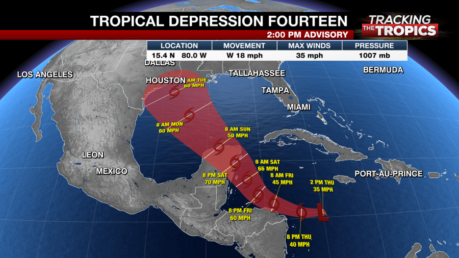
Another system located in the central Caribbean Sea became better organized and formed into Tropical Depression 14 on Thursday. It is also expected to become a tropical storm later Thursday.
In the latest advisory on the depression, issued at 11 p.m., the NHC said the system was about 65 miles east of Cabo Gracias a Dios. It’s moving west with 35 mph maximum sustained winds.

A Hurricane Watch has been issued for Punta Herrero to Cancun Mexico.
A Tropical Storm Watch has been issued from the Honduras/Nicaragua border westward to Punta Castilla, Honduras and for the Bay Islands of Honduras.
Tropical wave
The NHC is also monitoring a tropical wave over western Africa. The wave is producing disorganized showers and thunderstorms and is expected to move over the far eastern tropical Atlantic on Friday. It has just a 20% chance of developing over the next two days and a 40% chance of development over the next five days.
TRACKING THE TROPICS:
- Hurricane Idalia claimed 12 lives, caused $3.6B in damage, NHC report finds
- Tracking the Tropics ends for the season
- Tracking the Tropics team takes a look back at the 2023 hurricane season
- What does the El Niño weather pattern mean for winter?
- Late-season system in Atlantic has 60% chance of development, NHC says


