Editor’s note: This story is no longer being updated, please click here for the latest on the storm.
TAMPA, Fla. (WFLA) — Parts of Florida, including Tampa Bay, are bracing for potential heavy rain impacts from Tropical Storm Elsa as the system moves over Cuba with its sights set on the Florida Keys for Tuesday.
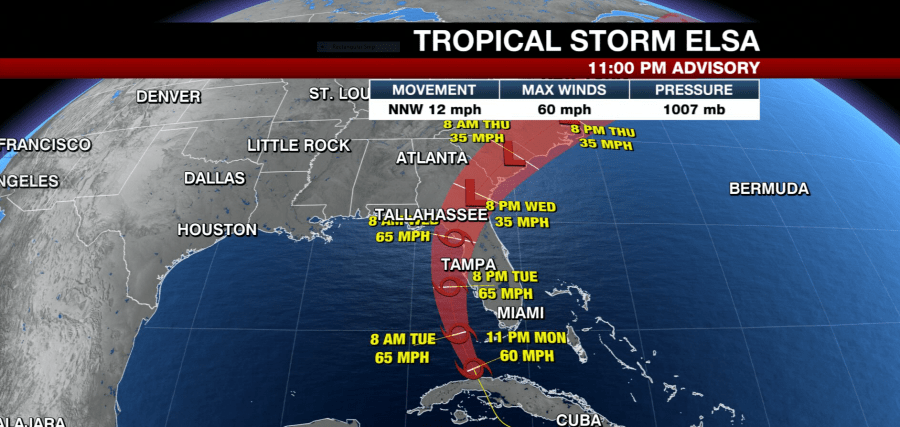
The National Hurricane Center’s 11 p.m. ET advisory says Elsa has finally moved over western Cuba, but still bringing heavy rains to the islands. The system is about 20 miles north-northeast of Havana and 80 miles south-southwest of Key West, moving north-northwest and about 12 mph.
Tropical Storm Elsa is forecast to move near the lower Florida Keys and the Dry Tortugas on Tuesday. The forecast track shows the storm pass near the Florida Keys early Tuesday before moving near or over parts of Florida’s west coast Tuesday and Wednesday.
Elsa weakened slightly Monday afternoon and currently has 60 mph maximum sustained winds with higher gusts. The storm is forecast to strengthen again a bit as it moves over water before reaching Florida.
According to the NHC, heavy rainfall could impact Florida and coastal Georgia through Wednesday, which could cause isolated flash, urban and minor river flooding. Later in the week, heavy rains could cause flooding in the coastal Carolinas.

Tropical storm conditions are expected to begin impacting the Florida Keys and parts of Florida’s west coast as soon as Monday night. The following watches and warnings are in effect:
Storm surge warning:
- West coast of Florida from Bonita Beach to the Aucilla River including Tampa Bay
Tropical storm warning:
- The Cuban provinces of Matanzas, Mayabeque, Havana, and Artemisa
- The Florida Keys from Craig Key westward to the Dry Tortugas
- West coast of Florida from Flamingo northward to Ochlockonee River
Storm surge watch:
- West of the Aucilla River to the Ochlockonee River
Tropical storm watch:
- West of the Ochlockonee River to Indian Pass, Florida


