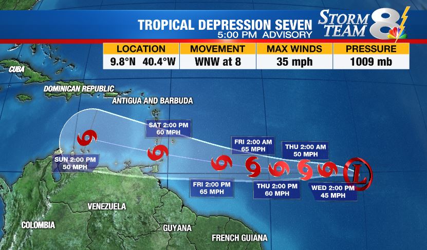
TAMPA, Fla. (WFLA) – Tropical Depression Seven developed in the central Atlantic Tuesday, per the National Hurricane Center, and is located roughly halfway between the Windward Islands and Africa.
The system will likely intensify into Tropical Storm Gonzalo, our seventh named storm of the season, at some point tonight or Wednesday. If so, Dr. Phil Klotzbach of Colorado State says Gonzalo would mark the earliest seventh named storm on record, edging out Gert from July 24 in 2005.
Tropical Depression Seven is currently located about 1,400 miles east of the Windward Islands and is moving west-northwest at 8 mph. Maximum sustained winds are near 35 mph.
Tropical Depression Seven will continue on a generally westward track crossing the Lesser Antilles and into the eastern Caribbean over the weekend. There is still considerable uncertainty with the longterm intensity of this system. It’s a newly-formed, tiny cyclone that will need to overcome some dry air and wind shear over the next several days.
Stay with Storm Team 8 as we continue to track the tropics. We’ll have a live update at 2 p.m. ET on Wednesday.
Elsewhere in the tropics
A tropical wave over western Cuba is producing disorganized showers and thunderstorms. Some gradual development is possible over the next few days as this disturbance drifts across the central Gulf Of Mexico.
The National Hurricane Center gives the system a 40% chance of tropical formation by the end of the week. Heavy rainfall is likely by the end of the week across the northwest Gulf Coast.
LATEST FROM TRACKING THE TROPICS:
- Hurricane Idalia claimed 12 lives, caused $3.6B in damage, NHC report finds
- Tracking the Tropics ends for the season
- Tracking the Tropics team takes a look back at the 2023 hurricane season
- What does the El Niño weather pattern mean for winter?
- Late-season system in Atlantic has 60% chance of development, NHC says