***This post has been archived. For the most up-to-date coverage of Fred, click here.
TAMPA, Fla. (WFLA) — Hurricane season is heating up with two storms tracking toward the United States. What was Tropical Depression Fred is now just remnants of the storm Saturday afternoon while newly formed Tropical Storm Grace is just getting organized.
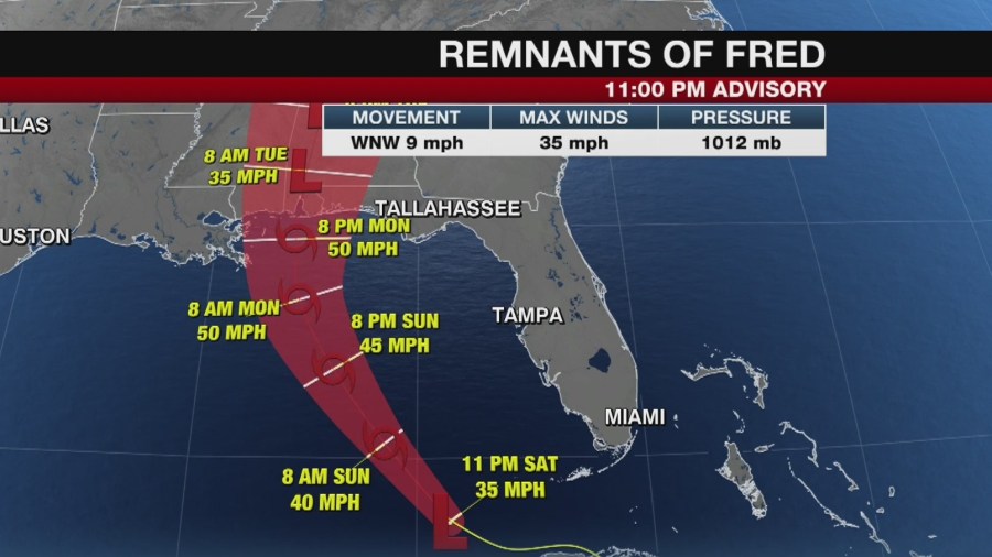
REMNANTS OF FRED
Despite degenerating to a tropical wave Saturday morning, Fred is forecast to re-develop on Sunday as it makes its way over the Gulf of Mexico.
Fred has spent the last 24 hours over Cuba and has weakened considerably due to the land interaction and continued strong upper-level winds.

While Fred remains in bad shape as of Saturday afternoon, forecast models still suggest it will re-gain the low-level circulation just north of Cuba. This would allow further re-organization over the warm Gulf of Mexico waters as it moves northwest toward the United States.
The National Hurricane Center says the remnants are moving toward the west-northwest near 9 miles per hour and this motion is expected to continue today. A turn toward the northwest is expected by tonight, followed by a northward motion by Sunday night. On the forecast track, Fred or its remnants are expected to pass west of the lower Florida Keys this afternoon, move across the eastern Gulf of Mexico tonight through Monday, and move inland over the northern Gulf coast Monday night.
Maximum sustained winds are near 35 miles per hour with higher gusts.
The National Hurricane Center forecast calls for Fred to redevelop into a tropical depression late tonight or on Sunday, with gradual strengthening to a tropical storm expected after the system re-develops.
There are no coastal watches or warnings in effect.
According to the NHC, interests in the northern coast of the Gulf of Mexico from Mississippi to the central Florida Panhandle should monitor the progress of the remnants of Fred. Watches could be required for portions of this area later in the weekend.
West Coast of Florida
The current forecast track keeps Fred well away from the west coast of Florida, however, impacts are still possible with Fred being asymmetric and unorganized. Most of the deeper tropical moisture and shower and thunderstorm activity associated with Fred will be on the eastern side, putting it closer to Florida’s peninsula.
There will be good coverage of storms both Saturday and Sunday in the Tampa Bay area due to the extra tropical moisture in place combined with the normal summer daytime heating. Localized flooding will the main hazard with Fred along the peninsula. Especially along coastal spots where up to five inches of rainfall has fallen over the past 4 days leading to saturated grounds. River flooding is possible along with standing water in ditches and on roads.
There will also be a low tornado threat Saturday night into Sunday with quick spin-up weak tornadoes possible.
Florida Panhandle
The panhandle of Florida will experience more impacts from Fred. The threat from storm surge will be low to the east of where the center comes ashore. The storm will not be large or strong enough to push large amounts of water onto the coastline. Freshwater flooding could be an issue in spots that have seen a significant amount of rain in the past few days.
The bulk of the heavy rain and gustiest winds will be on the eastern side as well. Rain bands will begin to move onshore to parts of the panhandle Monday morning with winds increasing throughout the day. Wind gusts upwards of 40-60 mph are possible in the strongest bands as Fred moves ashore.
Fred Moves Inland
Fred will quickly weaken as it moves inland but the tropical moisture will continue to surge northward bringing heavy rain to parts of the Tennessee River Valley through the middle of next week.


