This article is no longer being updated. You can find the latest story here.
TAMPA, Fla. (WFLA) — Subtropical Storm Nicole is expected to reach hurricane strength before it makes landfall, according to the National Hurricane Center.
At 10 p.m. ET Monday, Nicole was located about 415 miles east of the northwestern Bahamas and was moving northwest at 8 mph. It had maximum sustained winds of 45 mph, according to the National Hurricane Center.
Nicole is projected to move near the northwestern Bahamas on Tuesday before it turns north or northwest and approaches the east coast of Florida Wednesday night where a “prolonged period of hazardous weather” is expected.
The center said Nicole “could be near or at hurricane intensity by Wednesday or Wednesday night while it is moving near the northwestern Bahamas,” and that “a faster rate of strengthening [is] expected Tuesday night and Wednesday.”
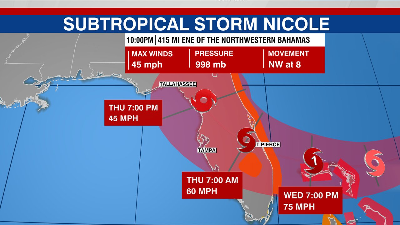
The storm is expected to dump 2 to 4 inches of rain on parts of the northwestern Bahamas and the central and northern parts of the Florida Peninsula Tuesday through Thursday, with some areas seeing isolated amounts of 6 inches.
Storm surges could raise water levels by as much as 3 to 5 feet above normal tide levels along the coast of the northwestern Bahamas.
The following areas could also see these rising levels:
- North Palm Beach to Altamaha Sound including the St. Johns River to the Fuller Warren Bridge — 3 to 5 ft
- St. Johns River south of the Fuller Warren Bridge to East Palatka — 2 to 4 ft
- Hallandale Beach to North Palm Beach — 2 to 4 ft
- North of Ocean Reef to Hallandale Beach including Biscayne Bay — 1 to 2 ft
Florida will likely see heavy rainfall from the system later this week.
A Hurricane Warning is in effect for:
- Northwest Bahamas, including the Abacos, Berry Islands, Bimini, and Grand Bahama Island
A Tropical Storm Warning is in effect for:
- Andros Island, New Providence, and Eleuthera
- Hallandale Beach to Altamaha Sound
- Lake Okeechobee
A Storm Surge Warning is in effect for:
- North Palm Beach to Altamaha Sound
- Mouth of the St. Johns River to Georgetown
A Hurricane Watch is in effect for:
- East Coast of Florida from the Volusia/Brevard County Line to Hallandale Beach
- Lake Okeechobee
A Storm Surge Watch is in effect for:
- Altamaha Sound to Hallandale Beach
A Tropical Storm Watch is in effect for:
- Altamaha Sound southward to Volusia Brevard County Line
- Hallandale Beach to north of Ocean Reef
Other areas to watch
Forecasters are watching another system about 650 miles east of Bermuda. The center gave it a 40% chance of developing into a tropical depression or storm sometime in the next 48 hours.
The center said a short-lived tropical storm could form Monday or Tuesday, but upper-level winds were expected to remain unfavorable for development, and it will dissipate and merge with a cold front.
The next named storm of the 2022 hurricane season would be Owen.