This story has been archived. For the latest on Hurricane Idalia’s path, click here.
TAMPA, Fla. (WFLA) — Idalia is now expected to make landfall in the Big Bend area of Florida as an “extremely dangerous” Category 4 hurricane, according to the National Hurricane Center.
As of the 11 p.m. update, the National Hurricane Center said Idalia is moving north at around 18 mph. The storm’s wind speeds have increased to 110 mph.
The storm is currently located 120 miles southwest of Cedar Key, according to the National Hurricane Center.
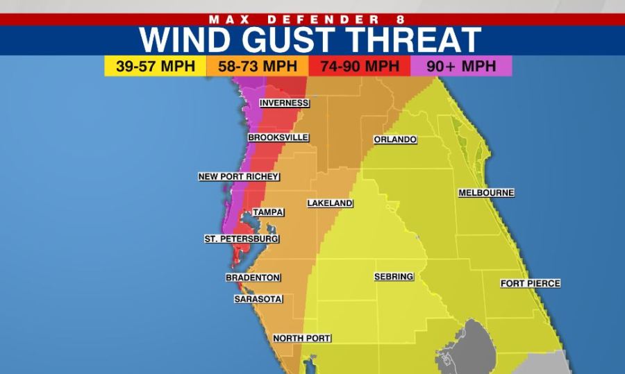
“There is the potential for destructive life-threatening winds where the core of Idalia moves onshore in the Big Bend region of Florida, with hurricane conditions expected elsewhere in portions of the Hurricane Warning area along the Florida Gulf Coast,” the National Hurricane Center said.
Parts of Florida’s Big Bend can see storm surge between 12 and 16 feet. Residents in coastal areas should listen to local officials.
Some areas north of Tampa Bay expected to see 6 to 11 feet of storm surge, with 4 to 6 feet in the Tampa Bay area and 3 to 5 feet south of Tampa Bay.
The storm surge threat is increased thanks to higher-than-normal high tides due to Wednesday’s Super Moon.
The National Hurricane Center said residents in these areas should be prepared for a long period of power outages.
A Storm Surge Warning is in effect for:
- Englewood northward to Indian Pass, including Tampa Bay
A Hurricane Warning is in effect for:
- Middle of Longboat Key northward to Indian Pass, including Tampa Bay
A Tropical Storm Warning is in effect for:
- Dry Tortugas Florida
- Chokoloskee northward to the Middle of Longboat Key
- West of Indian Pass to Mexico Beach
- Sebastian Inlet Florida to Surf City North Carolina
A Storm Surge Watch is in effect for:
- Bonita Beach northward to Englewood, including Charlotte Harbour
- Mouth of the St. Mary’s River to South Santee River South Carolina
- Beaufort Inlet to Drum Inlet North Carolina
- Neuse and Pamlico Rivers North Carolina
A Hurricane Watch is in effect for:
- Mouth of the St. Mary’s River to Edisto Beach South Carolina
A Tropical Storm Watch is in effect for:
- Lower Florida Keys west of the west end of the Seven Mile Bridge
- North of Surf City North Carolina to the North Carolina/Virginia
border - Pamlico and Albemarle Sounds

The worst weather will be between Tuesday night and Wednesday afternoon.
Most of the tornados will happen Tuesday night, while the biggest storm surge for the Tampa Bay area will happen Wednesday morning.
Idalia Resources
- Evacuations and Shelters
- How to Find Your Evacuation Zone
- School Closures
- Wednesday’s High Tide Times
- Sandbag Locations
Watch WFLA Now’s 24/7 coverage to stay up-to-date on Idalia. Get the latest on closings and weather conditions in your area on our Tracking the Tropics page.


