TAMPA (WFLA) – Hurricane season is still a few weeks away, but mother nature may have an early season surprise in store. There is some chance a subtropical storm may form next week off the East Coast and potentially move back south and west toward the Southeastern Seaboard.
Like many early-season storms – if the system forms – it is not expected to be strong, but it is a good reminder that we need to start preparing for hurricane season.
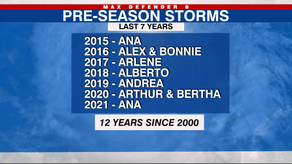
These pre-season reminders are becoming more common. Seven of the last seven hurricane seasons have featured a tropical or sub tropical system before June 1. Some seasons have featured two.
Below we discuss how this subtropical system may form, how it may affect Florida and why more named storms are forming before the official start of hurricane season.
Right now the system is just a dip in the upper-level jet stream moving across the country. By Sunday, the system will exit the coast off the Eastern U.S.
The blue colors under the L near Hatteras indicate this is a cold core upper-level low pressure. Cold core lows can not be classified as tropical systems – that is unless they transform – which happens from time to time.
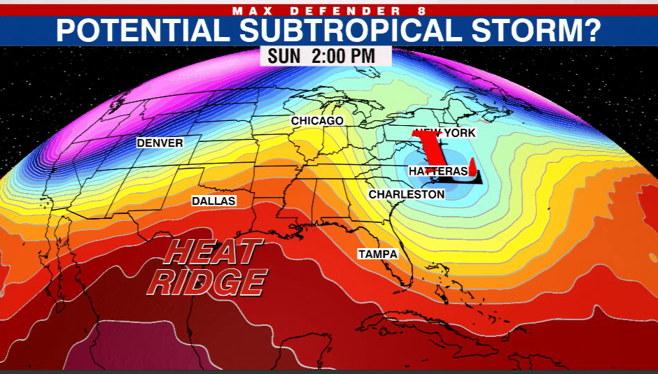
At that same time a heat dome will be building behind it over the nation’s middle and it will quickly elongate. Like an octopus the heat dome will reach around the storm system from its west to its north side.
The image below shows what we call a Rex block and it effectively captures the circulation, prohibiting the upper-level storm from moving north.
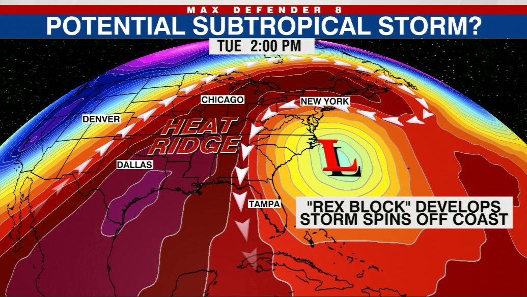
If you look closely at the two images above you will notice that between Sunday and Tuesday two things happen. First the storm (L) is forced southward by the block. Second, the colors under the L go from deep blue to aqua green. This means the core of the upper-level low is warming – essentially it is trying to transition from a cold to warm core. This is how many subtropical systems form.
The transition will be helped by the location of the low. It will be situated over warm water, adjacent to the Gulf Stream. The Gulf Stream is a narrow river of warm water which originates off our Tampa Bay coast in the Gulf of Mexico, swings around South Florida, and then parallels the Southeast coast.
We have a rule of thumb in meteorology. In order for a tropical storm to form the sea surface temperatures need to be close to, if not greater than an 80 degree threshold. Subtropical systems can form below that 80-degree threshold, but they still require warm water in the 70s and the Gulf Stream supplies that.
So, if this storm spends enough time over the warm waters and it can effectively transition to a quasi warm core low, then the National Hurricane Center may decide to give it a name. The name would be Alex. The chances of this happening are slightly less than even.
Regardless of whether this becomes a named storm, the impact will be the same. Expect large surf along the Eastern Seaboard and breezy, showery weather on the system’s western side.
The Tampa Bay Area will be far enough away from the circulation to avoid the rainfall most of next week. In fact, the counter clockwise flow will help spiral down dry air from the Appalachians, making for a much more comfortable week.
But even the possibility of a preseason storm begs the question, why are so many of these forming over the recent decade – nine in the last seven years? There are two explanations.
First, our technology is much better now than it was decades ago. Satellites have gotten better and so has the variety of other equipment meteorologists use. Now we can detect, analyze and identify storms much better.
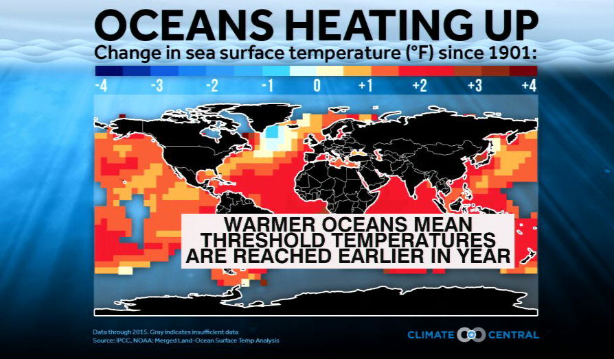
The second reason is the oceans are warmer than they used to be. Since 1900 the oceans have warmed an average of about 2 degrees Fahrenheit. This is due to human-caused greenhouse warming and, over the Atlantic basin, a decrease in atmospheric pollution which allows more sunlight in and warms the water more effectively.
Simply, the sea surface is reaching those threshold temperatures earlier in the season and further north as well. Thus, the time of year when tropical systems can form has expanded and the latitude at which they can form and sustain have expanded poleward.