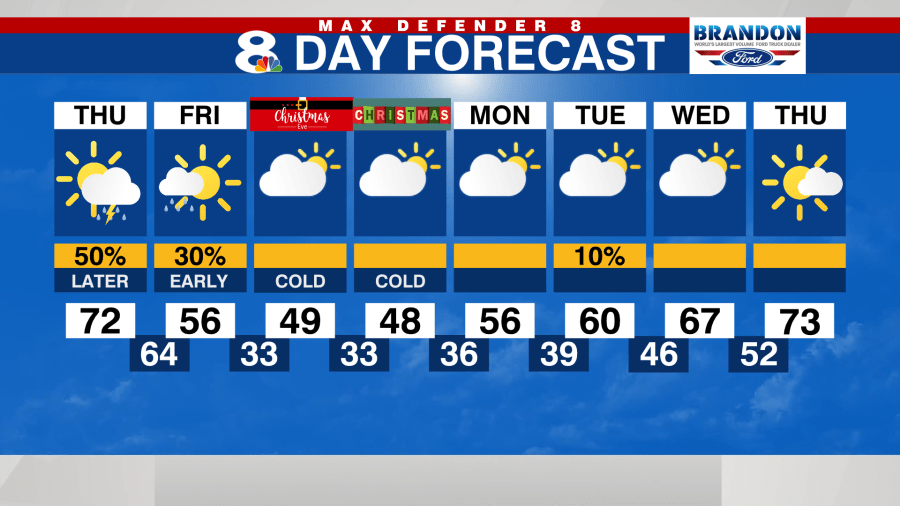
TAMPA, Fla. (WFLA) — Arctic air from the north pole has already begun to dive south across the United States. This plunge of very cold temperatures will make it as far south as the Tampa Bay area and it will linger for a few days.
The initial push of colder air will arrive Friday, with falling temperatures throughout the day as breezy winds bring in the chilly temps. The coldest of the weather will be Saturday and Sunday morning.
Temperatures will only slowly get warmer next week.
FRIDAY – Early showers, then colder
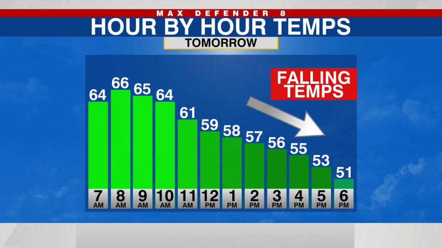
A thin line of light showers will pass from north to south Friday morning. This will precede the colder air and will not last long. Winds will pick up and turn out of the northwest shortly after the rain.

It will be an unusual day because instead of warming up in the afternoon, temperatures will be warmest in the morning and then FALL the rest of the day. Most areas will start out in the 60s until about 12 p.m.
After that, temperatures will fall through the 50s and by 5 p.m., they’ll likely be in the upper 40s with wind chills in the low 40s.
FRIDAY NIGHT – Coldest night
It’ll only continue to get colder and colder Friday night. Hard Freeze and Freeze Watches are in effect. The will be upgraded to warnings on Friday.
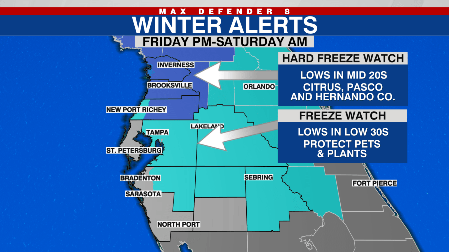
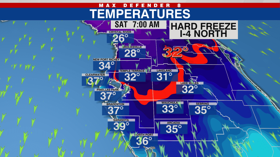
This means that temperatures will be in the upper 20s along the Nature Coast and low 30s along and south of I-4 for several hours. Make plans now to protect your plants and pets, as well as pipes along the Nature Coast.
SATURDAY – Cold all day
Temperatures will be in the 20s and 30s Saturday morning but the winds will still be breezy. Wind chills will be 20s in many locations across the Tampa Bay area through 10 a.m.

It will not warm up much after that cold start. Actual temperatures will be in the upper 40s briefly but wind chills will stay in the 30s all afternoon long. There will be a lot of sunshine but it will not help much.

SATURDAY NIGHT – Another cold night
Temperatures will quickly drop Saturday evening into the 30s. A few spots will drop into the upper 20s again along the Nature Coast. Freezing temperatures are likely everywhere else once again, with the exception of the immediate coastline.
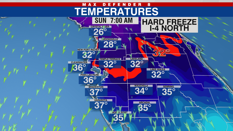
Hard Freeze and Freeze watches and warnings are likely to be in effect through Sunday morning.
SUNDAY – Another cold day
While we won’t be setting any cold weather records on Christmas day, it’ll be the coldest Christmas morning since 1995. Temperatures on Dec. 25th, 1995 hit 33 degrees at the Tampa International airport.
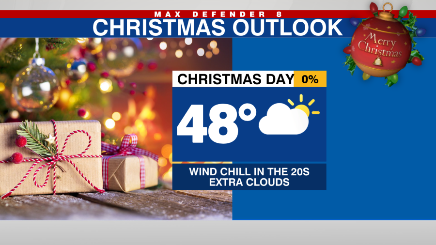
We won’t warm up all that much again either. After that cold start, temperatures will only warm back into the upper 40s. It will likely be the coldest Christmas day in 39 years when the high temperatures in 1983 was only 38 degrees at the Tampa airport. Wind chills will also keep it feeling festive and much colder all day.
NEXT WEEK – Slow warm up
The gradual warm-up will begin early next week. Lows will still be in the 30s for a few nights but above freezing in Tampa. Highs will be back in the 60s Monday and Tuesday and then back in the 70s late next week.