TAMPA, Fla. (WFLA) – We were cloudy (not as hot!) and breezy today with spotty downpours. We expect a few more showers and storms to drift westward through our area this evening. The rain should fade after sunset.
Overnight, expect gradually clearing skies and temperatures sinking down into the mid 70s. It’s been a hot minute (Ha ha!) since we cooled below the upper 70s and low 80s, so if you get out early, you may enjoy how nice it feels to be a few degrees cooler.
Friday starts out with sunshine. Expect a breezy warm up into the low 90s with building clouds. We expect scattered afternoon storms, especially between 2-7 p.m. Winds will be out of the east around 10 mph with some afternoon gusts closer to 20 mph.
Saturday now looks like the wetter day of the weekend. We may see a stray shower in the morning to mid day, but scattered showers and storms are expected during the afternoon into the early evening hours. Steamy afternoon temperatures will top out in the low 90s. Expect gusty winds out of the east, sustained between 10-15 mph and gusts as high as 20 mph.
Sunday starts out a tad on the cloudy skies, warming from the upper 70s into the low 90s. Expect a few afternoon showers and storms to pop up, and the easterly winds will be a little lighter.
The weather pattern remains in place on Monday, with a few scattered showers and storms, mainly in the afternoon and evening hours. Expect a sunny start and quick warm up into the low 90s.
Winds shift on Tuesday, instead of the easterly winds we have been enjoying, the winds will be southerly and westerly- this pattern means muggier and warmer overnight temperatures, only cooling down to around 80 degrees. Also chances for showers shift to coastal showers wandering onshore during the morning to midday. The onshore flow persists through the end of the work week.
TRACKING THE TROPICS
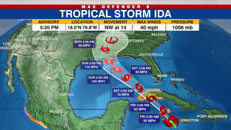
We are watching three areas in the tropics. Tropical Storm Ida has formed south of Cuba and is expected to intensify and move into the western Gulf over the weekend. Forecast models show the potential for rapid intensification into a hurricane, possibly a major hurricane (Category 3 or higher) before landfall near Louisiana. We will keep you updated.

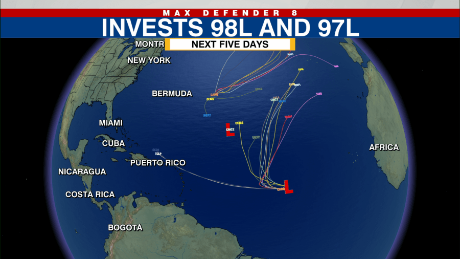
The other two areas in the Atlantic pose less of a threat to the US based on where they could form. Both systems have high chances to develop, but forecast models predict they move into the north Atlantic and do not impact the U.S.


