TAMPA, Fla. (WFLA) – Storms were pushed inland by our westerly breeze throughout the day and that pattern continues into the evening hours. Temperatures made it into the low 90s before the downpours pushed through.
The storms fade after sunset and we will be warm and muggy overnight. Temperatures will only get down into the low 80s by early Friday morning. Expect partly cloudy skies overnight.
Friday looks similar, with isolated morning coastal showers becoming more numerous by the middle of the day. The storms drift inland during the afternoon and evening hours. The coast will be generally drier by the evening hours. Temperatures will top out well into the low 90s.
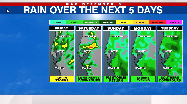
Saturday is a “transition day” out of this pattern. A few storms pop up around midday and linger into the evening. Your chances for rain on Saturday are 40%- making it the slightly drier day of the weekend. Temperatures will be hot, hitting the mid 90s during the afternoon.
By Sunday, we are back in a typical summer weather pattern with morning sunshine and late-day downpours that head toward the Gulf of Mexico. Your chances for rain are late in the day, but we expect 60% coverage of the storms.
It will be slightly hotter this weekend. Highs will still be in the low 90s Saturday, but we make it into the mid 90s Sunday.
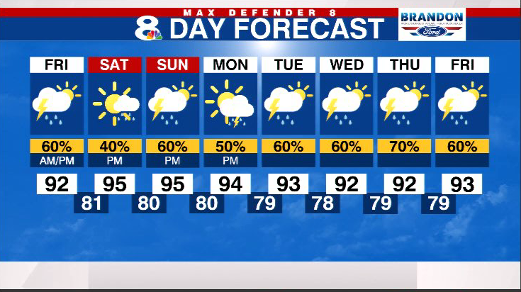
Highs remain in the low-mid 90s through next week. Expect scattered storms each day after 3pm.
We are still tracking one tropical wave in Central America because it may further organize in the southwestern Gulf of Mexico in the next five days. It should not have any impact to the state of Florida.

Stay weather aware on the go with the free Max Defender 8 Weather app. You can also sign up to get daily forecast newsletters and weather alert emails sent to your inbox.


