Jeff Berardelli is WFLA’s Climate Specialist
TAMPA, Fla. (WFLA) — Given the amount of warming humans have already imposed on the planet, nearly 2 degrees Fahrenheit, significant sea level rise is unavoidable even if we curb the burning of fossil fuels. That’s because warmer oceans will store the excess heat for centuries and that heat will continue to erode ice shelfs and destabilize ice sheets like Greenland and Antarctica.
The amount, and perhaps more importantly, the rate of sea level rise will depend on how successful humans are at curbing climate heating. We can slow the process down, allowing for the hundreds of millions of vulnerable people living near sea level to adapt and move. But there is evidence that over the course of centuries, multiple meters of sea level rise is likely unavoidable.
Sea level rise is notoriously hard to project far into the future mainly due to the inability to predict how stable or unstable large ice sheets will be. Although it is a low probability event in the near future, if a section of an ice sheet collapses, it’s not implausible to add a couple of feet of sea level rise in just a few decades.
So when projecting sea level rise into the future, agencies like NOAA use scenarios often based on the potential degree of global warming we may see in future decades, while also factoring in the uncertainty about ice sheet instability.
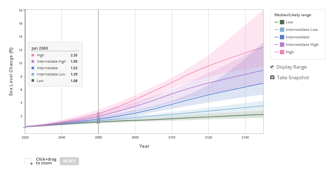
A 2022 NOAA report projects that in a middle-of-the-road (intermediate) scenario, by 2060 the Tampa Bay Area will see an increase of approximately 18 inches of sea level rise, relative to the year 2000. This graph is for St Petersburg.

By 2100, NOAA projects that rise in Tampa Bay could be 3-4 feet (relative to the year 2000) in an intermediate scenario. But to illustrate just how uncertain sea level rise forecasts can be, in the below NOAA graph a low scenario is only 19 inches and a high scenario is seven feet.

You can view the sea level rise scenarios for various locations along the US using this NOAA interactive map.
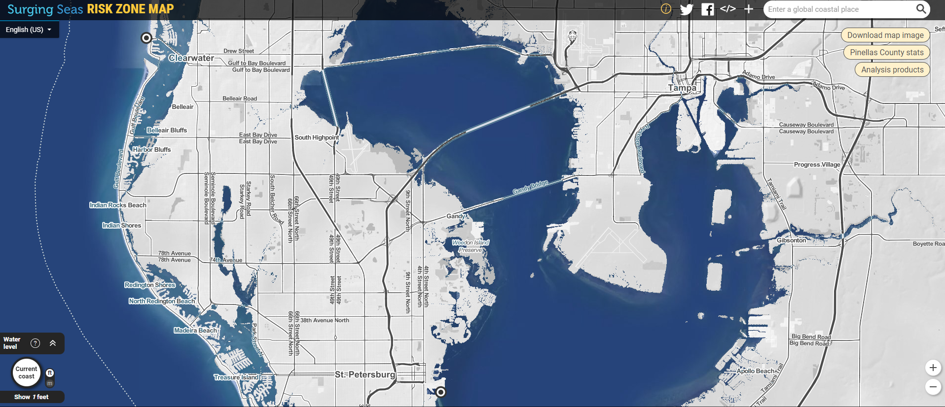
To give you an idea of just how much of the Tampa Bay Area would be underwater with three feet of sea level rise, here’s a depiction. Current sea levels are shown in the image on the left and a sea level rise of three feet is shown on the right. Move the cursor to reveal the change. As you can see much of the low-lying Tampa Bay properties would be underwater.


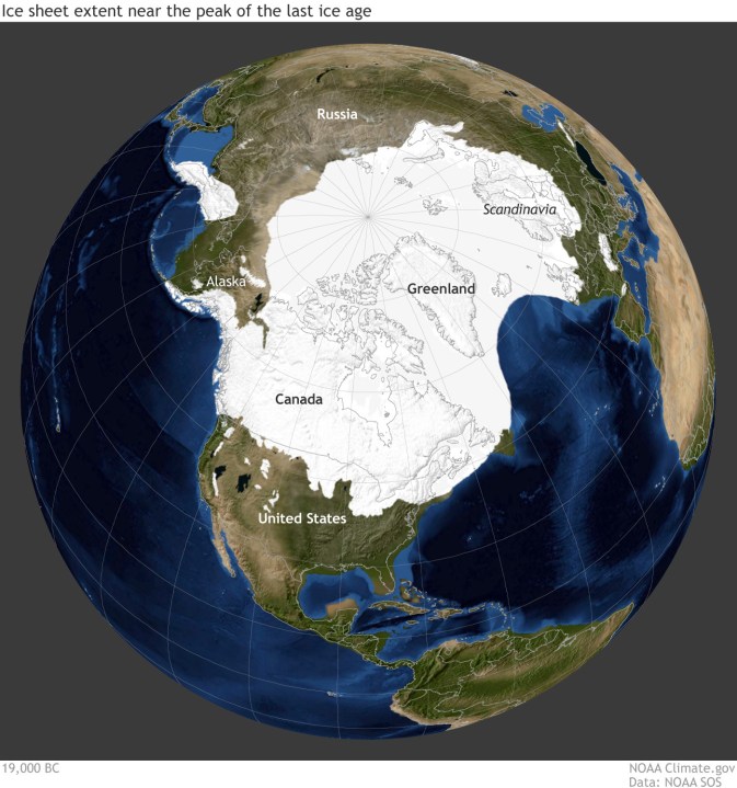
To better understand sea level rise, we need to know a little history. During the peak of the last ice age over 20,000 years ago, sea levels were 400 feet lower than they are today. That’s because much of the ocean water was trapped inside mile-high ice sheets that covered one-third of Earth’s land mass.
As seen by the map below from NASA of the last glacial maximum ice sheet coverage, you could walk 100 miles into where the Gulf of Mexico starts today from Florida’s west coast and you would still be on dry land, as evidenced by the brown shading west of Tampa.

When the last ice age ended, water ran off back into the oceans, and sea levels stabilized several thousand years ago. Below you can see a graph of sea levels of the last 2500 years from the Intergovernmental Panel on Climate Change. There was very little change until the 20th century when sea level rise began to shoot upward.

Since the Industrial Revolution sea level has risen by around 8-10 inches on average around the globe. It’s slow enough so that society can adapt. But the rate has been accelerating in recent years, more than doubling since the year 2000.

Right now sea level is rising at about five millimeters per year. If that rate of change were to hold steady (it won’t) then we’d see another seven inches by 2060. But we know from recent history and Earth’s accelerating warming that the rate is not stable and will likely double twice more before 2060.
So assuming the rate doubles twice from now to 2060, which seems reasonable given the graph above, then we’d see a sea level rise of roughly another 15 inches from today. That does not take into account any unexpected destabilizations of major ice sheets.
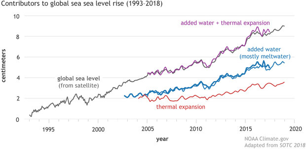
Now that estimate of 15 inches of course will vary from location to location based on multiple factors. What controls sea level rise in any given area is not just the melting of glacial ice, it is also the expansion of the water column due to warming oceans, changing ocean currents, and subsidence of local land.

As seen in the above image, in the distant past the most important factor was water column expansion due to heating. But for some time, and going forward, ice melting from ice sheets is the major factor.
The bottom line is we don’t know exactly how much the oceans will rise in the coming decades. The information presented here is a best estimate based on the available science. But given the uncertainty and distinct possibility that it could be several feet by 2100 if we want to be safe rather than sorry, this is what we should plan for.


