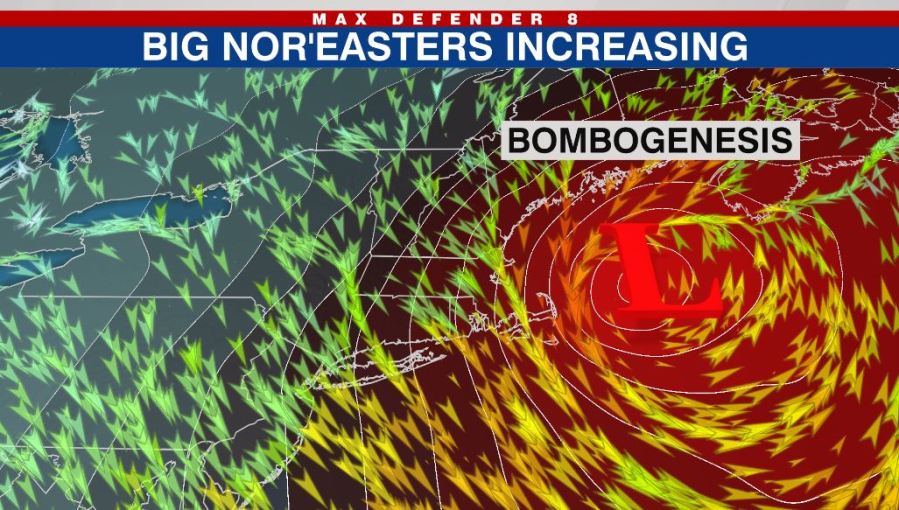
TAMPA (WFLA) – A Nor’easter, more intense than half of the hurricanes in the 2021 season, will take aim on the Northeast on Saturday. The blockbuster storm will dump more than 2 feet of snow on coastal New England, whip wind gusts past hurricane force and propel Arctic air and freezing conditions deep into Florida by Sunday morning.
And while winters have warmed significantly in Florida and up the Eastern seaboard, these high-impact Northeast snowstorms have become more common as of late – a lot more common.
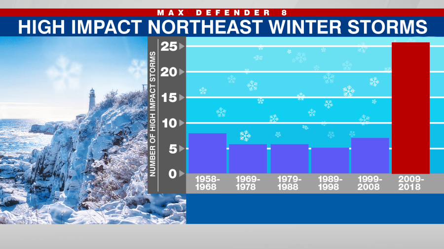
In the below graph, based on the NOAA’s Northeast Snowfall Impact Scale, you can see the large spike in high impact Northeast winter storms during the past decade. Between 1958 and 2008, the Northeast averaged about 6 major snowstorms per decade. But in the last decade that number quadrupled.
While there are likely multiple reasons for the spike in intense storms, what may be most surprising is, the most prominent connection appears to be warming waters due to climate change. In a 2015 paper, Dr. Andrew Pershing showed that the Gulf of Maine is warming faster than 99% of the global ocean – that’s the area just offshore Maine down to Cape Cod.
On the map of sea surface temperature anomalies (departure from normal) the area just offshore of the Northeast really jumps out with bright red-orange colors. This is the area where the Gulf Stream enters the Northern half of the Atlantic Ocean and where waters are warming the fastest. This is also the region where Nor’easters tend to intensify, gaining energy from the warm-moist waters, as cold Canadian air collides.
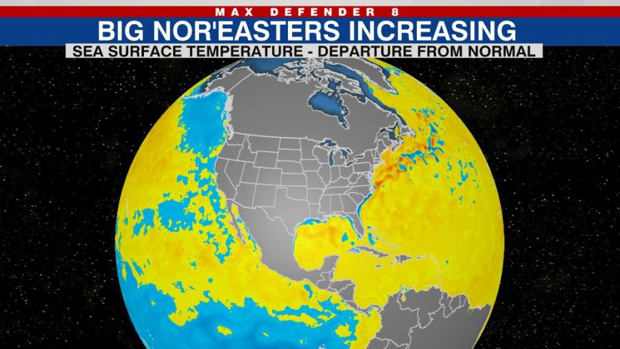
The fact that the oceans are warming is undisputed science. Each year the ocean sets a new record for high ocean heat content, as 90% of the excess heat from human-cause climate change is stored in the oceans. But some areas are warming faster than others and along the Northeast coast there is a well-known reason. The Gulf Stream is slowing down.
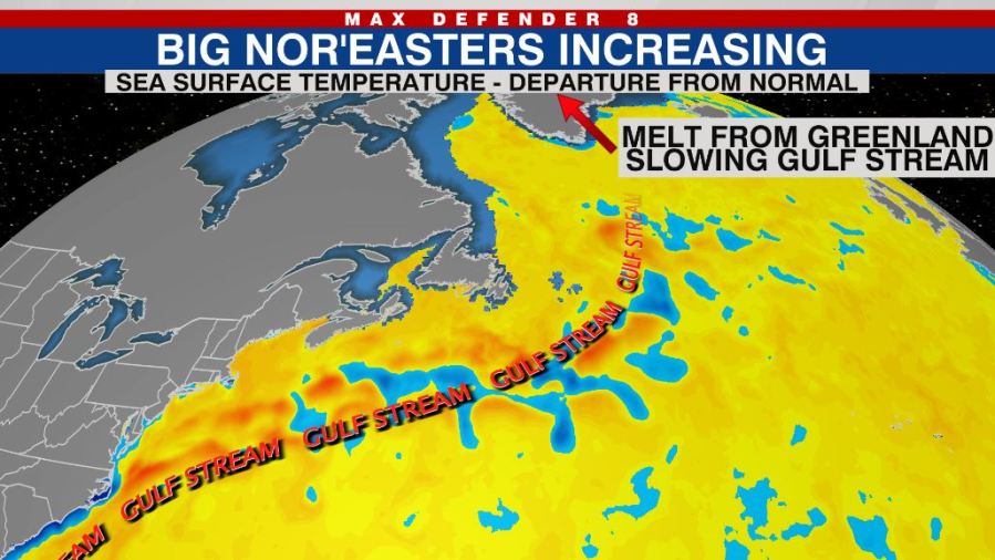
The Gulf Stream is a river of warm water originating near Florida, which flows up the East Coast spreading warm water north into the North Atlantic. But lately the Gulf Stream has been slowing down due to ice melting from Greenland. This fresh water flowing off Greenland is compromising the currents. Over the past century the Gulf Stream System has slowed by 15%.
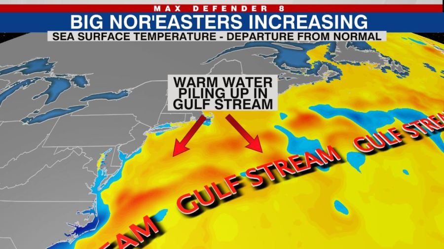
As a result of this slow down, warm water is piling up off the Northeast coast. The warming is not just taking place at the sea surface, it is happening below the surface as well.
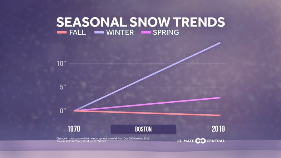
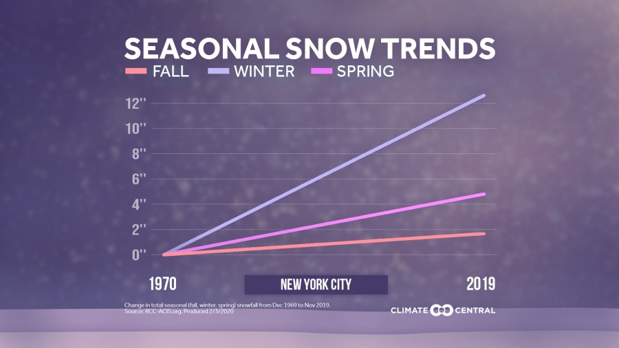
Dr. Judah Cohen is a well-known climate scientist from MIT and Atmospheric and Environmental Research who studies extreme winter weather. 8 On Your Side spoke to Cohen about this research. He says the data is clear that disruptive winter snow storms are increasing and the return period of heavy snowfalls is decreasing in cities like Boston and New York City – meaning they are happening more often. He agrees that the much above normal temperatures in the western North Atlantic could fuel more snowfall.
“Warmer sea surface temperatures (SSTs) can contribute to more moisture in the atmosphere, the more moisture the more it can rain or snow,” explains Cohen. “Also, if cold air passes off warming ocean temperatures it could favor more convection that can produce heavy precipitation.
In other words, warmer water not only supplies more moisture, but it can lead to more intense storm systems due to excess heat energy powering the storm’s engine. In the case of Saturday’s Nor’easter, the pressure drop of the storm may be almost twice as fast as the criteria for rapid intensification, also known as bombogenesis.
In the graphics below, the upward trend in winter snowfall is clear in both New York City and Boston.
But Cohen feels the connection to climate change is likely deeper than just warming waters off the Northeast Coast. He feels Arctic Amplification may be playing a role as well.
As predicted by climate models decades ago, the Arctic is indeed warming 2 to 3 times faster than the global average. Cohen feels this imbalance is throwing the steering currents off-kilter. His opinion is shared by many scientists in the climate community, although the exact mechanism is still debated.
Cohen’s area of expertise is the Stratospheric Polar Vortex (SPV), a spinning mass of cold air tens of thousands of feet above the Earth’s surface. His research reveals that changes in the ice and snow make-up of Arctic regions is changing the structure of the SPV.
Specifically, climate change seems to be disrupting and/or stretching the Polar Vortex, allowing for amplified jet streams driving cold shots south into the mid-latitudes. Now overall, the winters are warming substantially across the mid-latitudes, but in specific cases – like last winter’s Texas Cold Snap, these disruptions can lead to intense Arctic Outbreaks.
According to Cohen, “Severe winter weather including cold air or Arctic outbreaks and heavy snowfalls are more likely following a disrupted or weakened polar vortex. In my opinion, the increasing trend in days with a disrupted polar vortex is increasing,” Cohen says.
These magnified dips in the jet stream, colliding with warm Gulf Stream waters, not only lead to intense snow storms in the Northeast, but can also cause transient freezes in Florida.
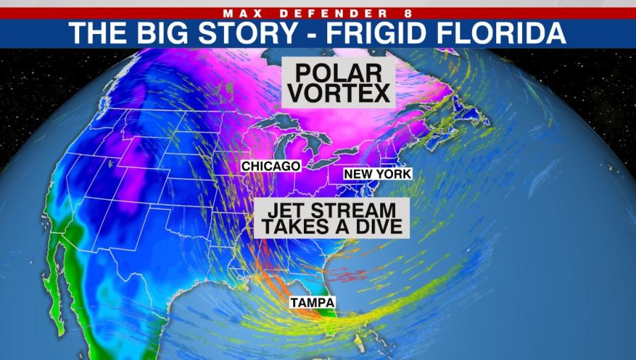
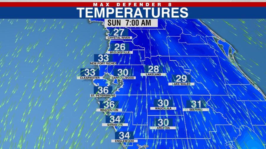
While the cold air will only last 2 days, temperatures will fall to between 25 and 35 by Sunday morning around the Bay Area, with a hard freeze likely east of I-75.
Despite the cold weekend ahead, overall winters in the Bay Area have warmed substantially since 1970. As seen below, we are now 4.5 degrees warmer than we were five decades ago.
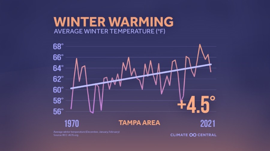
Historically speaking, Tampa’s temperature drops to or below freezing (32 degrees Fahrenheit) in 60% of winters. However, in the past 10 years, the mercury has only dropped below freezing one time because we are starting at a higher baseline. Given the historical record, the chance of such a mild stretch is only .20% or 1 in 500. With that said – in our now climate changed world – history is no longer as reliable a guide for today’s weather.


