TAMPA, Fla. (WFLA) — Three active systems are brewing in the tropics and being monitored by the National Hurricane Center: Tropical Storm Fred, Tropical Depression Grace and Tropical Storm Henri.
Tropical Storm Fred

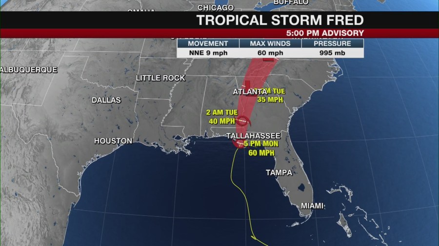
Tropical Storm Fred made landfall near Cape San Blas along the Florida Panhandle around 3:15 p.m. ET Monday with estimated maximum sustained wind speeds of 65 mph.
By 11 p.m., Fred’s maximum sustained winds had decreased to 40 mph as the storm moved inland. The storm is expected to move over western Georgia on Tuesday and across the southern Appalachian Mountains to West Virginia by Wednesday.
Tropical Depression Grace

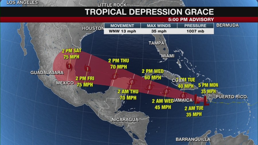
Grace was downgraded from a tropical storm to a tropical depression on Sunday but is forecast to strengthen and become a tropical storm again over the northwestern Caribbean Sea.
Tropical Depression Grace brought torrential rain to parts of Haiti and the Dominican Republic on Monday as it moved near Hispaniola. According to the 11 p.m. update from the NHC, Grace is about 100 miles southwest of Port Au Prince in Haiti with maximum sustained winds of 35 mph. Haiti is already dealing with the devastating aftermath of a 7.2-magnitude earthquake that hit Saturday, leaving more than 1,200 people dead and thousands more injured.
The system is forecast to pass near the southern coast of Hispaniola by Monday night before passing between Jamaica, Cuba and the Cayman Islands Tuesday. It’s then expected to approach Mexico’s Yucatan Peninsula Wednesday night.
According to the NHC, Grace will likely regain tropical storm status on Tuesday and could be near hurricane strength when it approaches the Yucatan Peninsula.
The NHC warns that heavy rainfall across the Dominican Republic, Haiti, Cuba, Jamaica and the Cayman Islands could lead to flash, urban and small stream flooding. The potential for mudslides is highest in Haiti and the Dominican Republic. There is also an “increasing risk of wind and rainfall impacts over the Yucatan Peninsula of Mexico” on Wednesday night and Thursday, the latest NHC update says.
A tropical storm warning is in effect for the Cayman Islands and the southern coast of the Cuban provinces of Santiago de Cuba, Granma, Las Tunas and Camaguey. A tropical storm watch is in effect for Jamaica, the coasts of the Dominican Republic and Haiti and the southern coast of the Cuban provinces of Ciego de Avila, Sancti Spiritus, Cienfuegos, Matanzas and Isla de la Juventud.
Tropical Storm Henri

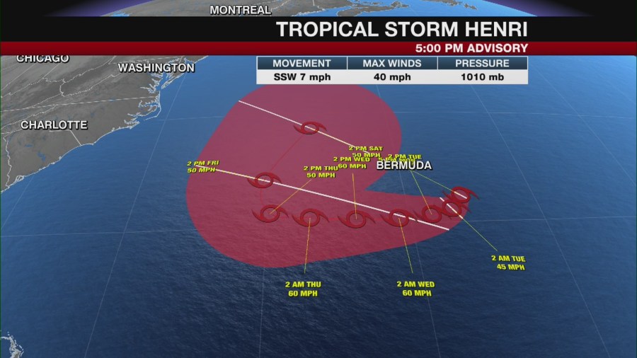
Tropical Depression 8 strengthened to become Tropical Storm Henri Monday evening, with maximum sustained winds at 45 mph as of the NHC’s 11 p.m. advisory.
The depression is about 145 miles southeast of Bermuda and moving south-southwest at 5 mph. The NHC says the system is expected to pass “well to the south of Bermuda” Tuesday.
A tropical storm watch is in effect for Bermuda.
Looking ahead
Other than the three active systems currently in the Atlantic, the National Hurricane Center is not monitoring anything else.
However, a tick up in tropical activity is expected this time of year as we move closer to Sept. 10, which is the statistical peak of the Atlantic hurricane season. On average, more than 60 percent of all tropical systems form in August or September.
The National Oceanic Atmospheric Administration said earlier this month an above-average hurricane season is still expected thanks to atmospheric and oceanic conditions staying conducive as we head into those active months.


